In September, I went on a 15-day trip from Cairns to Cape York, the northernmost tip of the Australian continent. I will introduce the state of the trip along with the details of the places visited. I hope to include a lot of useful information for everyone reading this article to plan their Cape York trip.
The article on “Part ①: From Cairns to Chile Beach” is here

The article on “Part ②: To the Old Telegraph Track” is here

Day 8 of the trip, finish the Old Telegraph track and head further north
This is a continuation of the previous article. On the 8th day of the trip, we just finished the northern part of the Old Telegraph track and came out to Bamaga Road, the bypass route. From here it is 24 km to the Jardine River Ferry Terminal.
By the way, it is 170km from Bramwell Roadhouse via Bamaga Road to the Jardine River Ferry Terminal without going through the Old Telegraph Track. Regarding the bypass route, when I asked people who passed this route, they said that the corrugation was quite bad and they couldn’t go that fast. So even if you go through here, I think it’s good to make a plan with plenty of time.
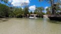
Jardine River Ferry
This Jardine River Ferry is the only way to cross the Jardine River and head further north. You have to go through here to get to Cape York.

This is also a gas station, so you can refuel. You can buy ferry tickets inside this office.

EFTPOS only. It seems that you can buy ferry tickets online in advance.


When we arrived, there was only one car in front of us, so we were able to cross immediately without waiting. The ferry crossing takes just a few minutes. However, it seems to be very crowded when it is crowded. Depending on the time of day, you may have to wait for several hours. By the way, it seems that the ferry does not move between 12:00 and 13:00 during the staff’s lunch break. It may be better to avoid around noon.
Bamaga
Cross the Jardine River by ferry and continue for another 35km to the small town of Injinoo. The road was paved just before arriving in this town. How comfortable!
In addition, there was a town called Umajico a few kilometers ahead, but I didn’t have any places to stop by, so I passed by quickly and headed for the town called Bamaga, which is just ahead.
Bamaga is a fairly large town (population 1164 in 2016 survey). Gas stations, supermarkets, pharmacies, liquor stores, pubs, restaurants, post offices, hospitals, car repair shops, and more.

We arrived in Bamaga around 3:30pm and rushed to the supermarket, which closes at 4:00pm, to do some grocery shopping.
There was a pharmacy next to the supermarket, but it wasn’t open on the Saturday we went. It seems that the weekend is closed.

Fuel prices are cheaper at Bamaga than at the small gas stations along the way, so we came here with enough capacity and filled up here. I also supplied water along with refueling.
Drinkable water is available at the BP petrol station in Bamaga. So I filled up the water tank here. Water is in a 60L bladder, 20L tank, and 10L tank for a total of 90L.
The BP petrol station here in Bamaga is the northernmost place where you can refill drinking water.
Cape York Camping Punsand Bay
In Bamaga, I bought more food, replenished with fuel and water, and from here I drove Pajinka Road and Punsand Bay Road, 26km from Bamaga, and finally, Cape York Camping, the northernmost campground in Australia. We arrived at Cape York Camping Punsand Bay.

We arrived on the 8th day of our trip and stayed here for 4 nights. By the way, I made a reservation for this campsite six months ago. Only here you can’t get it if you don’t make a reservation in advance and as soon as possible. When we checked in, we heard that more than 100 people were on the waiting list every day. Please think that it is unlikely that you can get a site by jumping in without a reservation.
Reservations can be made via website.

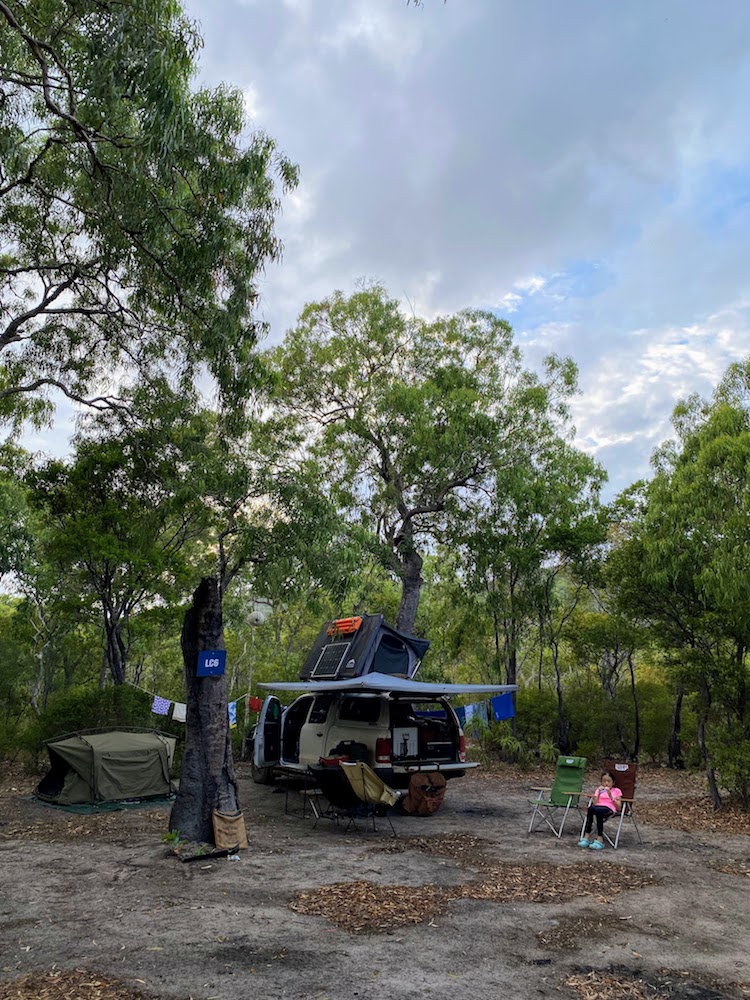
Accommodation here includes cabins, powered sites, and unpowered sites, and for unpowered sites, you can choose beachfront or bush sites. The beachfront is literally right on the beach and the views are great, but the wind would have seriously affected it so we chose a bush site. It’s about 50m from the bush site to the beach, so you can walk to the beach immediately.

The site was surrounded by trees to some extent, and there was shade, and one section was quite large, so I was able to use it comfortably.

Finding a good spot was easy, as the ground was easy to find. Swag is of course, but there is a rooftop tent, so the car must be parked on a flat surface.
Our camp setting
I will briefly introduce the setting of our campsite. As for the setting this time, the rooftop tent is Drifta Stockton’s Wildland Rooftop Tent 1.2m version.


It’s a hard shell type, and you can attach a roof bar on top of the roof top tent, where you can attach a solar panel and a recovery board. 1.2m is the width of the mattress, so it’s a double size. Two people sleep here. My wife and daughter were mainly sleeping.
Another is the Nebula 1550 Swag from the Australian brand Darche.


This one is 1550mm wide, so it’s a queen size, and the mattress is a swag with a thickness of 50mm. My son and I mainly slept in this.
Of the 14 nights, I slept in the rooftop tent only 2 nights, and my daughter and son took turns sleeping in a wife & son and me & daughter pair.
This is our best setting. Especially for this trip it was ideal. Best of all, it takes 10 minutes each to set up and pack up. 2 minutes to the roof top tent, 5 minutes to the swag, then take out the chairs and table and you’re done.
It’s good to be able to quickly prepare and set up even when you stay overnight after a long-distance move, pack up the next morning, and then go on a long-distance move again. So you can leave the swag set in place to secure your campsite, and the rooftop tent can be quickly folded up and ready to go.
Since I stopped sleeping with four people in a family tent, I have tried various styles, but the rooftop tent and swag combination is the fastest, easiest, and most comfortable. In addition, the swag is placed on the roof bar when moving, so all the sleeping equipment fits on the roof, and the space inside the canopy has expanded at once, which is a big change.
Day 9 of the trip, relaxing at PunSand Bay
On the eighth day, I arrived at PunSand Bay at 5:30 pm, set up, had dinner, and went to bed early.
And on the 9th day, I spent a leisurely time at PunSand Bay without traveling long distances. I ate breakfast, finished the laundry that had piled up, and then took a walk around the campsite.

Head to the beach first. After passing through the beach front site, the beach spreads out in front of you. It’s a punsand bay, so it’s a bay.
Don’t make the mistake of swimming here. Crocodile habitat.

It was cloudy on this day, but sometimes there was a beautiful blue sky. It feels good to walk barefoot on the sandy beach.

After walking on the beach, go to the bar restaurant in front of the reception. Morning, noon, night and business hours are fixed, but business hours were always crowded and crowded. We didn’t eat at the restaurant, but the oven-baked pizza looks delicious.

There was such a boat bar on the beach in front of the restaurant. The sake you drink here is also delicious. Great view!

This is the main spot for children. It had a pool. It’s right in front of the beach, but of course you can’t swim on the beach, so it’s great to have a pool. This day was also very hot, so I was playing here from the morning.
The Croc Tent
There is a souvenir shop called The Croc Tent in a place you definitely want to stop by near Punsand Bay.

It is located at the intersection that turns from Bamaga through Pajinka Road to Punsand Bay Road, so you will definitely pass by when going to Punsand Bay, and it will be in a place that catches your eye.

There are many products such as shirts, hats, towels and accessories, so this is probably the best place to buy souvenirs from Cape York.
I bought a shirt and my son bought this hat.

Cape York Tip
Well, I went there this evening. Cape York Tip, The Tip, there are various names, but it is the northernmost tip of the Australian continent.
First, go back on Punsand Bay Road, turn left at Croc Tent, and head further north on Pajinka Road. 17km from Croc Tent.

This will bring you to the Cape York Walking Trail parking lot. From here you can walk to Cape York. It’s not right off the parking lot.

Climb a rocky area first and then descend gently. It took me about 15-20 minutes walking slowly.

It’s best to wear proper shoes if possible. I saw people who were there climbing up with beach sandals and beer in hand. .

And I found it at the tip of the cape. It’s that sign.

“You are standing at the northernmost point of the Australian continent”
This is Cape York, the northernmost point of the Australian continent. I took a solid commemorative photo.
Day 10 of the trip, go to the Three Islands Tour
On the 10th day of the trip, I went on a one-day tour called the Three Island Tour, which I had made a reservation for in advance.

The Three Islands Tour is a one-day tour of three islands, Horn Island, Thursday Island, and Roko Island, located in the southern part of the Torres Strait off the Cape York Peninsula. Departure is from the jetty in the small town of Seisia.
It’s a 40 minute drive from Punsand Bay where I was staying. Return to Bamaga and from there take the Seisia Road to the departure point Seisia Pier. The road from Bamaga to Seisia is paved all the way.
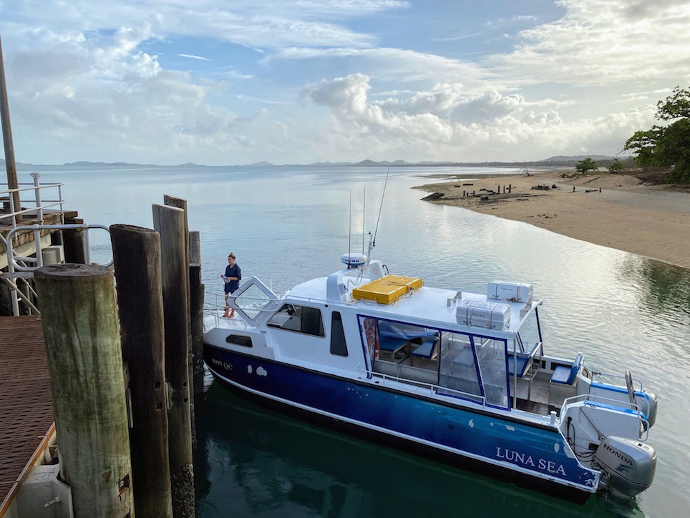
The boat departs at 8:00, and the meeting is at 7:45, 15 minutes before. Punctuality. We left Punsand Bay at 6:45 with plenty of time to spare, so we arrived before 7:30. There are also toilets at the pier parking lot.
At the meeting time, check your name on the boarding list and pay the tour fee before boarding. Then get on the boat and leave when everyone is ready.
First, go to Horn Island
About an hour after leaving Seisia, we arrived at the first island, Horn Island.

Attach a boat to a small jetty and land. From here, the boat crew will guide you to the island on foot.

Walk about 10 minutes and visit the Torres Strait Heritage Museum.


This museum had a lot of various materials and photographs related to the Second World War. And there were many materials in Japanese.

In addition to materials related to the war, there are also many paintings and sculptures on display that show the culture of the indigenous people of the Torres Strait Islands. There are so many interesting things to see that time flies by unexpectedly.

After visiting the museum, on the way back to the boat, I found a place called Supermarket & Cafe, so I stopped by. Buy cold drinks and ice cream here, take a short break and replenish your energy. The weather was fine and it was a very hot day.
The stay on Horn Island was about an hour and a half. Our next destination is Thursday Island, the island in front of us that can be seen from the pier.
Next Thursday Island
From Horn Island to Thursday Island is a short trip. We got there in 10 minutes.

There are covered benches right next to the boat dock. It feels like a waiting room. The sun is very strong, so we try to stay in the shade as much as possible while walking around the tour.

Well, here too, when I get off the boat, I will walk with the crew. After about 5 minutes, we arrived at a cafe on the seaside street.
There will be some time set aside here for those who want to grab a coffee or a snack. It’s also a restroom break.
On Thursday Island, van taxis are available in front of this cafe, and you can visit sightseeing spots while going around the island with a local driver guide.
The tour around the island by taxi started at 11:00. We started by going through Thursday Island’s main street and up the hill.
Green Hill Fort
Our taxi tour first visited Green Hill Fort It is a fortress built on a hill.
The Torres Strait Islands are an area that plays an important role in separating Australia from other countries, and were built as a coastal defense facility to prevent invasion of Australia. It was later listed as a heritage site.

The view from the top of the hill is wonderful. Horn Island, which I visited first, can be seen slightly to the left, and the Australian continent can be seen far away on the far right. I also like the color of the sea.

This view would have been the best place for a fortress on a hill. There was a cannon, and under it was a door that allowed you to go underground. It has served as Australia’s front line of defense.
Here, I had time to get off the taxi and walk around for about 10-15 minutes. Please enjoy the superb view from the top of the hill.
Thursday Island Cemetery
After Green Hill Fort, go down the hill and go clockwise around the outer road of the island.
All facilities such as police, hospitals, schools, and government offices are gathered on this small Thursday Island, and it seems to play a role as the administrative center of the Torres Strait Islands.
This is because of the geographical advantage of Thursday Island, which is surrounded by large islands and is protected from natural disasters such as cyclones, so major public facilities have gathered one after another. .
We came to the north side of the island and came to the next stop.

This is the Japanese cemetery on Thursday Island.
I knew there was a Japanese cemetery on Thursday Island, and I knew that tours would visit it.

So we actually got here on a taxi tour.
On Thursday Island, a small island in Australia far from Japan, far from the mainland, so many graves are built in a quiet place in front of the sea outside the center of the town. It’s in Japanese characters.
The moment I saw this, I felt very nostalgic, and I don’t know why, but tears came to my eyes.
On the memorial tower, it is written in Japanese as follows.
“This memorial tower was erected to comfort the spirits of the approximately 700 Japanese who died in the Torres Sea area and to pass on their achievements to future generations. From 1878 to 1941, the Japanese were a key industry in northern Australia. He was hired to fish for pearl oysters, takase oysters, and sea cucumbers that had been in the past, working with the people of the island to discover fishing grounds and improve fishing methods to develop this fishing industry. August 1979 Memorial Tower Construction Association built here to commemorate the 100th anniversary of the arrival of the Japanese to the island with donations from pearl farming companies in this sea area, etc.
Even if you live in Australia, it’s a place you don’t get to visit often. The time I spent there was about 10-15 minutes, but I was able to spend a valuable time.
1.5 hours of free time
After visiting the Japanese cemetery, we went around and came back to near the starting point. And the tour ends when we arrive in front of The Grand Hotel. we arrived after 12:00, so the tour was 1 hour.
1:30 pm is the departure time for the boat to the next island, so we have about an hour and a half. Just as I was getting hungry, we had lunch at the pub restaurant attached to the hotel. After that, we still had time, so we stopped by the souvenir shops along the main street, walked along the coast, and spent our time as we liked.
At 1:30pm, we will return to the boat and head to the next island.
Lastly to Roko Island
Leaving Thursday Island, we headed towards the Australian continent, right near Seisia, and the last island we visited was Roko Island. As you can see from the map, it is a very small and cozy island.

First of all, I was surprised at the pier where the boat was parked. The wooden pier is attached to a drum and floats on the surface of the water.

And, of course, if you walk on it, it will sway. I was a little worried that there were places half sunk on the way, but I landed safely.
Immediately after entering the island, coffee, tea, cold water, and biscuits were prepared as welcome drinks.

There is a bar next to it where you can also buy soft drinks and alcohol.

After arriving and having a drink, you can take a walk around the island with an island guide. It’s such a small island.
I was resting in a hammock with my daughter who was a bit seasick and limp.

Roko Island has accommodation, and it seems that you can stay overnight. During your stay, you can enjoy walking, fishing, reading, etc. in the relaxed atmosphere of this small island.
We spent about an hour and a half here, leaving Roko Island at 4:00 and returning to Seisia around 4:30, ending our three island day tour.
Day 11 of the trip, explore more around Cape York
On the 11th day of the trip, I didn’t have anything in particular planned for this day. After arriving at the site, if there is something I want to do or a place I want to go to, I will make a schedule.
Fishing at Seisia Pier
The morning started slowly. Even if I say it, I’m up at 6 o’clock. On this trip, I went to bed at 9pm, so it’s a good life to go to bed early and wake up early.

DOD’s rabbit sandwich maker was a big success on this trip. DOD is of course famous in Japan, but here in Australia, Drifta handle DOD, and you can purchase it locally here.

There were many days when I made hot sandwiches for breakfast. If you put the ingredients properly, just sandwich it and bake it. It’s easy and delicious, and the rabbit’s grilled mark is cute, so the kids were happy to eat it.

I had ham & cheese & tomato, ham & egg, and hash potato.
By the way, after having breakfast, I went to the pier of Seisia, which I went to on the Three Island Tour the day before. It seems that this place is famous for fishing, and I saw many people fishing from the morning when the tour gathered.

Since it’s a pier, you can fish with peace of mind even with your children. The kids were a few, but they were able to catch them. It looks like it’s fun.
DC3 plane crash site and wreckage

We fished until early afternoon and had lunch, and in the afternoon we went to see one spot, DC3, where the plane crash site and its wreckage are located. I thought it would be a good idea to take a picture and post it, so please take a look at the link.
After that, I returned to Punsand Bay and spent the rest of my time relaxing at the campsite.
Day 12 of the trip, leave Punsand Bay and start heading south
We spent 4 nights at Cape York Camping Punsand Bay and were able to see a lot of Cape York and its surroundings. There are still many places I want to go, but this is enough for this time.


On the 12th day of the trip, we left Punsand Bay and started heading south towards Cairns.
From here on in the next article. Continue to Part 4: From Punsand Bay to Cairns